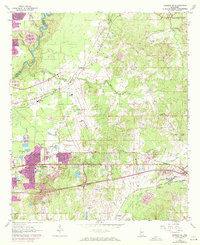
1963 Map of Jackson SE
USGS Topo · Published 1972About this map
Thompson Field and the expanding residential corridors of McLaurin Heights anchor this study of the eastern Jackson metropolitan area during a period of significant growth. The Pearl River forms a natural boundary to the west, while the northern edge of the sheet shows the Ross R Barnett Reservoir at its early capacity. The landscape is a mix of industrial and suburban development, evidenced by the Fish Hatchery, various Sewage Disposal Ponds, and a Cement Plant.
Find a feature on this map
49 named features on this map. Tap any name to fly to it.
Don’t see what you’re looking for? This feature index may not catch every label — zoom into the map to look around manually.
Map Details
Editions of this 1963 Jackson SE Map
3 editions found
Other maps of this area

1903 · Jackson
USGS Topo · 1:125,000

1905 · Jackson
USGS Topo · 1:48,000

1906 · Florence
USGS Topo · 1:62,500

1908 · Jackson
USGS Topo · 1:62,500

1908 · Florence
USGS Topo · 1:62,500

1922 · Pelahatchee
USGS Topo · 1:48,000

1924 · Pelahatchee
USGS Topo · 1:62,500

1950 · Pelahatchie
USGS Topo · 1:62,500

1952 · Pelahatchie
USGS Topo · 1:62,500

1953 · Meridian
USGS Topo · 1:250,000