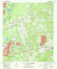
1980 Map of Jackson SE
USGS Topo · Published 1986About this map
The Pearl River corridor in Rankin County serves as the backdrop for rapid suburban expansion and infrastructure development in this late-twentieth-century study. The landscape is dominated by the massive footprint of Thompson Field, complete with its associated US Weather Station and pumping facilities. Surrounding this aviation hub, the growth of residential communities like McLaurin Heights, Crossgates, and Castlewoods reflects the mid-century urbanization of the area east of Jackson. This period of development is caught in transition, where new housing tracts sit adjacent to long-standing extractive industries like the numerous sandpits and quarries scattered near Greenfield.
Find a feature on this map
65 named features on this map. Tap any name to fly to it.
Don’t see what you’re looking for? This feature index may not catch every label — zoom into the map to look around manually.
Map Details
Editions of this 1980 Jackson SE Map
2 editions found
Other maps of this area

1903 · Jackson
USGS Topo · 1:125,000

1905 · Jackson
USGS Topo · 1:48,000

1906 · Florence
USGS Topo · 1:62,500

1908 · Jackson
USGS Topo · 1:62,500

1908 · Florence
USGS Topo · 1:62,500

1922 · Pelahatchee
USGS Topo · 1:48,000

1924 · Pelahatchee
USGS Topo · 1:62,500

1950 · Pelahatchie
USGS Topo · 1:62,500

1952 · Pelahatchie
USGS Topo · 1:62,500

1953 · Meridian
USGS Topo · 1:250,000