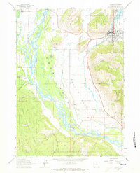
1963 Map of Jackson
USGS Topo · Published 1973About this map
Jackson serves as the focal point of this Wyoming landscape, positioned beneath the northern slopes of Snow King Mountain. The 1962 topography reveals a town deeply integrated with its surrounding natural barriers and protected lands, including the Elk Refuge National to the north and the expansive Teton National Forest to the south. The braided channels of the Snake River dominate the valley floor, creating a complex network of waterways fed by Fish Creek and Cottonwood Creek. Cultural landmarks such as a Drive-in Theater and the Fish Creek Landing Strip reflect the mid-century development of the region, while landmarks like West Gros Ventre Butte and East Gros Ventre Butte define the valley's distinct geological character. This survey captures a moment when the regional infrastructure, including Melody Landing Strip, was beginning to formalize around the traditional ranching and recreational landscapes.
Find a feature on this map
32 named features on this map. Tap any name to fly to it.
Don’t see what you’re looking for? This feature index may not catch every label — zoom into the map to look around manually.
Map Details
Editions of this 1963 Jackson Map
3 editions found
Other maps of this area

1899 · Grand Teton
USGS Topo · 1:125,000

1901 · Grand Teton
USGS Topo · 1:125,000

1931 · Jackson
USGS Topo · 1:125,000

1935 · Jackson
USGS Topo · 1:125,000

1955 · Driggs
USGS Topo · 1:250,000

1958 · Driggs
USGS Topo · 1:250,000

1962 · Driggs
USGS Topo · 1:250,000

1963 · Munger Mountain
USGS Topo · 1:24,000

1963 · Jackson
USGS Topo · 1:24,000

1963 · Teton Pass
USGS Topo · 1:24,000