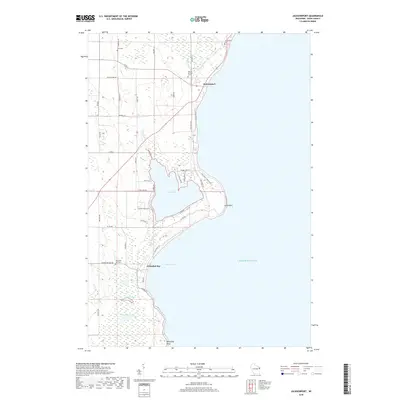
2018 Map of Jacksonport
USGS Topo · Published 2018About this map
Jacksonport sits as a lakeside focal point on the Door Peninsula, where the landscape is defined by the sweeping indentation of Whitefish Bay and the massive expanse of Lake Michigan. This 2018 survey highlights a delicate balance between coastal settlement and protected wetlands, notably around the inland Clark Lake, which is separated from the lake by a narrow strip of land. Local history and genealogy are well-represented by several burial grounds including Jacksonport Cem, Whitefish Bay Cem, and Holy Nativity Cem, marking the long-standing communities along the shore. To the south, the map details the intricate hydrography of Arbter Lake and Schwartz Lake, surrounded by dense wetlands and smaller waterways like Logan Cr and Hibbard Cr. The eastern edge is dominated by dramatic coastal features such as Cave Point and Whitefish Point, showing the geological character of this renowned Wisconsin shoreline.
Find a feature on this map
45 named features on this map. Tap any name to fly to it.
Don’t see what you’re looking for? This feature index may not catch every label — zoom into the map to look around manually.
Map Details
Editions of this 2018 Jacksonport Map
This is the sole edition of this map. No revisions or reprints were ever made.
Other maps of this area

1954 · Escanaba
USGS Topo · 1:250,000

1954 · Manitowoc
USGS Topo · 1:250,000

1957 · Escanaba
USGS Topo · 1:250,000

1958 · Escanaba
USGS Topo · 1:250,000

1958 · Manitowoc
USGS Topo · 1:250,000

1960 · Sturgeon Bay
USGS Topo · 1:62,500

1960 · Jacksonport
USGS Topo · 1:62,500

1960 · Sister Bay
USGS Topo · 1:62,500

1961 · Chambers Island
USGS Topo · 1:62,500

1981 · Institute
USGS Topo · 1:24,000