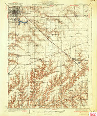
1937 Map of Jacksonville
USGS Topo · Published 1937About this map
Jacksonville serves as the primary hub of this west-central Illinois landscape, where a dense network of iron rails and schoolhouses defines the Depression-era rural economy. The Wabash RR, Alton RR, and Burlington and Quincy RR converge in the county seat, radiating outward past smaller settlements like Pisgah and Woodson. The concentration of specialized institutions, including the Douglas Institute and Routt Sch, suggests a community of significant educational and social standing for the period.
Find a feature on this map
79 named features on this map. Tap any name to fly to it.
Don’t see what you’re looking for? This feature index may not catch every label — zoom into the map to look around manually.
Map Details
Editions of this 1937 Jacksonville Map
2 editions found

Other maps of this area

1909 · Tallula
USGS Topo · 1:62,500

1923 · Carlinville
USGS Topo · 1:48,000

1924 · Winchester
USGS Topo · 1:48,000

1924 · Waverly
USGS Topo · 1:62,500

1924 · Roodhouse
USGS Topo · 1:62,500

1925 · Carlinville
USGS Topo · 1:62,500

1926 · Winchester
USGS Topo · 1:62,500

1926 · Waverly
USGS Topo · 1:62,500

1926 · Roodhouse
USGS Topo · 1:62,500

1929 · Arenzville
USGS Topo · 1:62,500