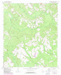
1971 Map of Jacksonville NE
USGS Topo · Published 1988About this map
Turnpike Creek and its many tributaries carve through this Georgia landscape, defining the rural character of Telfair County during the early 1970s. The settlement at Cedarpark and the surrounding woodlands are punctuated by numerous local landmarks that reveal a deeply established community. The map shows a high density of rural religious and commemorative sites, including James Chapel, Mims Ch, and Mt Calvary Ch, alongside family-named burial grounds such as Silver Cem and Livingston Cem. The drainage network, featuring Sugar Creek and Horse Creek, illustrates how the terrain dictated road placement and land use. Purple revisions on this edition indicate changes in woodland cover and field boundaries observed in the early 1980s, providing a look at the shifting agricultural footprint in the area around Green Grove Ch and Dodge Chapel.
Find a feature on this map
19 named features on this map. Tap any name to fly to it.
Don’t see what you’re looking for? This feature index may not catch every label — zoom into the map to look around manually.
Map Details
Editions of this 1971 Jacksonville NE Map
2 editions found
Other maps of this area

1953 · Waycross
USGS Topo · 1:250,000

1957 · Macon
USGS Topo · 1:250,000

1958 · Macon
USGS Topo · 1:250,000

1958 · Waycross
USGS Topo · 1:250,000

1964 · Macon
USGS Topo · 1:250,000

1970 · Scotland
USGS Topo · 1:24,000

1970 · Jordan
USGS Topo · 1:24,000

1971 · Roper
USGS Topo · 1:24,000

1971 · Jacksonville NE
USGS Topo · 1:24,000

1971 · Snipesville
USGS Topo · 1:24,000