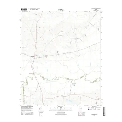
2014 Map of Jacksonville
USGS Topo · Published 2014About this map
Jacksonville serves as the focal point of this South Georgia landscape, situated near the winding border where Telfair, Coffee, and Ben Hill counties meet. The area is defined by the significant river bottomlands surrounding Mill Creek, Alligator Cr, and Gregory Cr, which drain into the larger water system at the southern edge of the sheet. The terrain transitions from these low-lying creeks to higher ground where local landmarks like Coffee Bluff and Barr Bluff overlook the water.
Find a feature on this map
65 named features on this map. Tap any name to fly to it.
Don’t see what you’re looking for? This feature index may not catch every label — zoom into the map to look around manually.
Map Details
Editions of this 2014 Jacksonville Map
This is the sole edition of this map. No revisions or reprints were ever made.
Other maps of this area

1953 · Waycross
USGS Topo · 1:250,000

1958 · Waycross
USGS Topo · 1:250,000

1971 · Jacksonville NE
USGS Topo · 1:24,000

1971 · Snipesville
USGS Topo · 1:24,000

1971 · Broxton NE
USGS Topo · 1:24,000

1972 · Cooks Still
USGS Topo · 1:24,000

1972 · Broxton North
USGS Topo · 1:24,000

1972 · Jacksonville
USGS Topo · 1:24,000

1972 · China Hill
USGS Topo · 1:24,000
1972 · Workmore
USGS Topo · 1:24,000