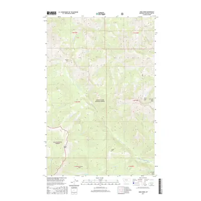
2017 Map of Jakie Creek
USGS Topo · Published 2017About this map
Lewis & Clark National Forest and Lolo National Forest converge in this high-altitude landscape dominated by the Lewis and Clark Range. The topography is defined by significant drainage systems including the Dearborn River and the N Fork Blackfoot River, which carve through the terrain near the Carmichael Basin. High mountain transitions are marked by named crossings such as Welcome Pass and Elk Pass, which historically provided passage between the forested drainages. Natural features like Twin Lakes and Tobacco Valley suggest protected pockets within the steep slopes. The map details an intricate network of waterways like Jakie Creek, Smith Cr, and Pass Cr, illustrating how the watershed divides the wilderness. This map is a record of the backcountry trails and forest boundaries that shape the recreation and conservation history of western Montana.
Find a feature on this map
37 named features on this map. Tap any name to fly to it.
Don’t see what you’re looking for? This feature index may not catch every label — zoom into the map to look around manually.
Map Details
Editions of this 2017 Jakie Creek Map
This is the sole edition of this map. No revisions or reprints were ever made.
Other maps of this area

1903 · Coopers Lake
USGS Topo · 1:125,000

1955 · Choteau
USGS Topo · 1:250,000

1957 · Choteau
USGS Topo · 1:250,000

1958 · Choteau
USGS Topo · 1:250,000

1962 · Choteau
USGS Topo · 1:250,000

1968 · Heart Lake
USGS Topo · 1:24,000

1968 · Olson Peak
USGS Topo · 1:24,000
1968 · Caribou Peak
USGS Topo · 1:24,000
1970 · Scapegoat Mountain
USGS Topo · 1:24,000
1970 · Steamboat Mountain
USGS Topo · 1:24,000