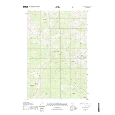
2020 Map of Jakie Creek
USGS Topo · Published 2020About this map
Lewis & Clark National Forest and Lolo National Forest converge in this high-altitude landscape along the Lewis and Clark Range. The Continental Divide National Scenic Trail winds through the center of the sheet, crossing notable high points such as Welcome Pass and Elk Pass. This 2020 survey documents the complex drainage systems that flow away from the divide, including Lost Cabin Creek and the Dearborn River. Human presence is marked by the Steamboat Lookout perched above Bunch Grass Basin, serving as a critical vantage point for forest management. The geography transitions from the steep peaks of the range into more sheltered areas like Tobacco Valley and Carmichael Basin, providing a detailed look at the wilderness corridor as it appeared in the early 21st century.
Find a feature on this map
48 named features on this map. Tap any name to fly to it.
Don’t see what you’re looking for? This feature index may not catch every label — zoom into the map to look around manually.
Map Details
Editions of this 2020 Jakie Creek Map
This is the sole edition of this map. No revisions or reprints were ever made.
Other maps of this area

1903 · Coopers Lake
USGS Topo · 1:125,000

1955 · Choteau
USGS Topo · 1:250,000

1957 · Choteau
USGS Topo · 1:250,000

1958 · Choteau
USGS Topo · 1:250,000

1962 · Choteau
USGS Topo · 1:250,000

1968 · Heart Lake
USGS Topo · 1:24,000

1968 · Olson Peak
USGS Topo · 1:24,000
1968 · Caribou Peak
USGS Topo · 1:24,000
1970 · Scapegoat Mountain
USGS Topo · 1:24,000
1970 · Steamboat Mountain
USGS Topo · 1:24,000