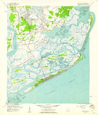
1959 Map of James Island
USGS Topo · Published 1960About this map
Secessionville and Centerville anchor this detailed coastal survey of the South Carolina lowcountry during the late 1950s. The landscape is a complex network of barrier islands and tidal marshes, featuring James Island, Morris Island, and Folly Island. At Lighthouse Point, the map reveals the maritime infrastructure of Charleston Harbor, including the Loran Coast Guard Station and nearby Loran Tower.
Find a feature on this map
71 named features on this map. Tap any name to fly to it.
Don’t see what you’re looking for? This feature index may not catch every label — zoom into the map to look around manually.
Map Details
Editions of this 1959 James Island Map
4 editions found
Other maps of this area

1918 · Kiawah Island
USGS Topo · 1:21,120

1919 · Johns Island
USGS Topo · 1:21,120

1919 · The Jetties
USGS Topo · 1:21,120

1919 · Wadmelaw Island
USGS Topo · 1:62,500

1919 · Charleston
USGS Topo · 1:21,120

1919 · James Island
USGS Topo · 1:21,120

1919 · Fort Moultrie
USGS Topo · 1:21,120

1919 · Legareville
USGS Topo · 1:21,120

1920 · Ravenels
USGS Topo · 1:62,500

1943 · Fort Moultrie
USGS Topo · 1:24,000