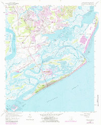
1959 Map of James Island
USGS Topo · Published 1984About this map
Secessionville and the surrounding marshlands of James Island reveal a coastal landscape in transition during the late 1950s. While residential developments like Centerville and Riverland expand south of Charleston, the southern reaches of the island remain dominated by tidal flats and a dense network of waterways including James Island Creek and Folly River. The map highlights the educational infrastructure of the era, noting James Island High Sch and several local institutions such as Kings Road Sch and Meggett Sch. Along the coast, Folly Beach shows an established street grid fronting the Atlantic Ocean, while nearby Morris Island remains largely undeveloped, anchored by the Loran Coast Guard Station at its southern tip. This survey captures the region just before significant modern suburbanization reached the outer sea islands.
Find a feature on this map
55 named features on this map. Tap any name to fly to it.
Don’t see what you’re looking for? This feature index may not catch every label — zoom into the map to look around manually.
Map Details
Editions of this 1959 James Island Map
4 editions found
Other maps of this area

1918 · Kiawah Island
USGS Topo · 1:21,120

1919 · Johns Island
USGS Topo · 1:21,120

1919 · The Jetties
USGS Topo · 1:21,120

1919 · Wadmelaw Island
USGS Topo · 1:62,500

1919 · Charleston
USGS Topo · 1:21,120

1919 · James Island
USGS Topo · 1:21,120

1919 · Fort Moultrie
USGS Topo · 1:21,120

1919 · Legareville
USGS Topo · 1:21,120

1920 · Ravenels
USGS Topo · 1:62,500

1943 · Fort Moultrie
USGS Topo · 1:24,000