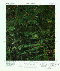
1977 Map of Jamiesons Line Station
USGS Topo · Published 1978About this map
The international border between New York and Quebec defines this landscape, where the Jamieson Line Station U S Customs and Jamieson Line Canadian Customs facilitate movement across a rural agricultural corridor. This 1970s orthophoto map reveals a region of small settlements and family-named roads, such as Sam Cook Road and Flynns Line Road, set against a backdrop of woods and fields. The Riviere Chateauguay and Trout Creek wind through the terrain, supporting local industry at Cooks Mill.
Find a feature on this map
38 named features on this map. Tap any name to fly to it.
Don’t see what you’re looking for? This feature index may not catch every label — zoom into the map to look around manually.
Map Details
Editions of this 1977 Jamiesons Line Station Map
This is the sole edition of this map. No revisions or reprints were ever made.
Other maps of this area

1915 · Chateaugay
USGS Topo · 1:62,500

1915 · Malone
USGS Topo · 1:62,500

1917 · Malone
USGS Topo · 1:62,500

1943 · Chateaugay
USGS Topo · 1:62,500

1948 · Ogdensburg
USGS Topo · 1:250,000

1951 · Ogdensburg
USGS Topo · 1:250,000

1953 · Ogdensburg
USGS Topo · 1:250,000

1961 · Ogdensburg
USGS Topo · 1:250,000
1964 · Chateaugay
USGS Topo · 1:24,000
1964 · Burke
USGS Topo · 1:24,000