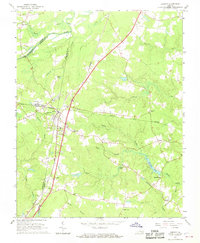
1966 Map of Jarratt
USGS Topo · Published 1968About this map
Jarratt serves as the focal point of this mid-1960s landscape, situated at the junction of the Seaboard Coast Line Railroad and the Norfolk and Western Railway. The town's infrastructure includes the Jefferson Sch and several local congregations like Morning Star Ch. This rail crossroads sits along the dividing line of Sussex and Greensville counties, illustrating how transportation corridors shaped regional development.
Find a feature on this map
42 named features on this map. Tap any name to fly to it.
Don’t see what you’re looking for? This feature index may not catch every label — zoom into the map to look around manually.
Map Details
Editions of this 1966 Jarratt Map
4 editions found
Other maps of this area

1919 · Jarratt
USGS Topo · 1:62,500

1919 · Mc Kenney
USGS Topo · 1:48,000

1919 · Emporia
USGS Topo · 1:62,500

1919 · Arringdale
USGS Topo · 1:48,000

1920 · Arringdale
USGS Topo · 1:62,500

1921 · Mc Kenney
USGS Topo · 1:62,500

1942 · Arringdale
USGS Topo · 1:62,500

1942 · Emporia
USGS Topo · 1:62,500

1943 · Mc Kenney
USGS Topo · 1:62,500

1951 · Jarratt
USGS Topo · 1:62,500