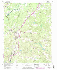
1966 Map of Jarratt
USGS Topo · Published 1986About this map
The town of Jarratt serves as a central hub at the meeting point of the Seaboard Railroad and the Norfolk and Western lines. This transit-focused settlement is surrounded by a rural landscape defined by numerous watercourses, including the Nottoway River and Poplar Swamp. The map reveals a dense network of community landmarks, particularly country churches like First Baptist Ch, Morning Star Ch, and High Hill Ch that anchor the local social fabric.
Find a feature on this map
36 named features on this map. Tap any name to fly to it.
Don’t see what you’re looking for? This feature index may not catch every label — zoom into the map to look around manually.
Map Details
Editions of this 1966 Jarratt Map
4 editions found
Other maps of this area

1919 · Jarratt
USGS Topo · 1:62,500

1919 · Mc Kenney
USGS Topo · 1:48,000

1919 · Emporia
USGS Topo · 1:62,500

1919 · Arringdale
USGS Topo · 1:48,000

1920 · Arringdale
USGS Topo · 1:62,500

1921 · Mc Kenney
USGS Topo · 1:62,500

1942 · Arringdale
USGS Topo · 1:62,500

1942 · Emporia
USGS Topo · 1:62,500

1943 · Mc Kenney
USGS Topo · 1:62,500

1951 · Jarratt
USGS Topo · 1:62,500