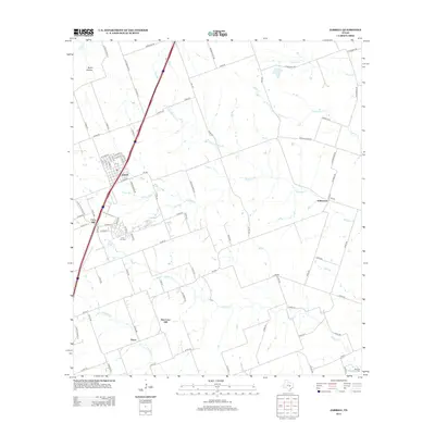
2012 Map of Jarrell
USGS Topo · Published 2012About this map
Jarrell serves as the primary hub of this north Williamson County landscape, situated at the intersection of local routes like FM-487 and the major north-south interstate corridor. The geography is defined by a dense network of seasonal waterways, including Willis Cr, Donahoe Cr, and Opossum Cr, which carve through the blackland prairie. Settlement patterns reveal the historical shift from older agricultural centers to modern developments. For example, the map shows Corn Hill and the nearby Corn Hill Cem, alongside the later community of New Corn Hill, illustrating how local populations migrated as transportation routes evolved. To the east, the village of Schwertner sits near the headwaters of Indian Cr, while the small community of Theon anchors the southern portion of the sheet. Rural life is further represented by family-named landmarks like Bone Hollow and a grid of county roads that connect these dispersed farming settlements.
Find a feature on this map
95 named features on this map. Tap any name to fly to it.
Don’t see what you’re looking for? This feature index may not catch every label — zoom into the map to look around manually.
Map Details
Editions of this 2012 Jarrell Map
This is the sole edition of this map. No revisions or reprints were ever made.
Other maps of this area

1885 · Taylor
USGS Topo · 1:125,000

1887 · Taylor
USGS Topo · 1:125,000

1893 · Georgetown
USGS Topo · 1:125,000

1894 · Taylor
USGS Topo · 1:125,000

1925 · Georgetown 4-b
USGS Topo · 1:48,000

1928 · Round Rock
USGS Topo · 1:62,500

1949 · Round Rock
USGS Topo · 1:62,500

1951 · Round Rock
USGS Topo · 1:62,500

1954 · Austin
USGS Topo · 1:250,000
1958 · Youngsport
USGS Topo · 1:24,000