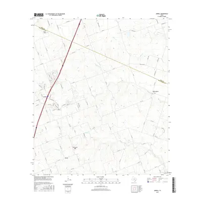
2016 Map of Jarrell
USGS Topo · Published 2016About this map
Jarrell and the surrounding Williamson County countryside are defined by a network of farm roads and winding prairie creeks. The settlement pattern here includes the small communities of Theon and New Corn Hill, alongside the village of Schwertner to the east. Local history is anchored by the Corn Hill Cem and Denison Cem, while the landscape is carved by several prominent watercourses including Donahoe Cr and Willis Cr. North of the town center, Bone Hollow and Indian Cr mark the higher elevations near the Bell County line. The map illustrates a region transitioning from traditional rural farmsteads to a more connected corridor, with Interstate 35 bisecting the terrain and the grid of residential streets expanding around the core of Jarrell.
Find a feature on this map
88 named features on this map. Tap any name to fly to it.
Don’t see what you’re looking for? This feature index may not catch every label — zoom into the map to look around manually.
Map Details
Editions of this 2016 Jarrell Map
This is the sole edition of this map. No revisions or reprints were ever made.
Other maps of this area

1885 · Taylor
USGS Topo · 1:125,000

1887 · Taylor
USGS Topo · 1:125,000

1893 · Georgetown
USGS Topo · 1:125,000

1894 · Taylor
USGS Topo · 1:125,000

1925 · Georgetown 4-b
USGS Topo · 1:48,000

1928 · Round Rock
USGS Topo · 1:62,500

1949 · Round Rock
USGS Topo · 1:62,500

1951 · Round Rock
USGS Topo · 1:62,500

1954 · Austin
USGS Topo · 1:250,000
1958 · Youngsport
USGS Topo · 1:24,000