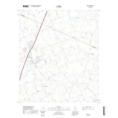
2019 Map of Jarrell
USGS Topo · Published 2019About this map
Jarrell and its surrounding communities in Williamson County are depicted here as they appeared in the late 2010s, showing a landscape defined by both traditional rural settlements and modern residential expansion. The growth of Sonterra south of the primary town center contrasts with the enduring agricultural layout of places like Theon and New Corn Hill. This area is characterized by a dense network of watercourses, including Willis Cr and Donahoe Cr, which carve through the terrain as they flow toward the east. Genealogists and local historians can find significant landmarks such as Corn Hill Cem and Denison Cem, providing clear points of reference for tracing family history in the region. The map also delineates the Bell Co and Williamson Co border, marking the northern extent of this central Texas corridor.
Find a feature on this map
102 named features on this map. Tap any name to fly to it.
Don’t see what you’re looking for? This feature index may not catch every label — zoom into the map to look around manually.
Map Details
Editions of this 2019 Jarrell Map
This is the sole edition of this map. No revisions or reprints were ever made.
Other maps of this area

1885 · Taylor
USGS Topo · 1:125,000

1887 · Taylor
USGS Topo · 1:125,000

1893 · Georgetown
USGS Topo · 1:125,000

1894 · Taylor
USGS Topo · 1:125,000

1925 · Georgetown 4-b
USGS Topo · 1:48,000

1928 · Round Rock
USGS Topo · 1:62,500

1949 · Round Rock
USGS Topo · 1:62,500

1951 · Round Rock
USGS Topo · 1:62,500

1954 · Austin
USGS Topo · 1:250,000
1958 · Youngsport
USGS Topo · 1:24,000