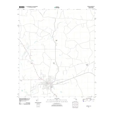
2011 Map of Jasper
USGS Topo · Published 2011About this map
The Little Alapaha River snakes through this northern Florida landscape, defining the rural character of Hamilton County at the start of the 21st century. The map centers on the community of Jasper, where the street grid transitions into a network of country roads like Crews Rd and County Hwy-249. For genealogists, the map is particularly useful for locating several burial grounds including Evergreen Cemetery, White Chimney Cemetery, Nunn Cemetery, and Geiger Cemetery, which are scattered across the surrounding pine and wetlands. Local industry and historical settlement patterns are visible in place names like Bakers Mill, Rawls, and Kennedy Still, suggesting the agricultural and timber roots of the region. To the southwest, the terrain is marked by Tiger Creek and the small basin of Clardy Lakes, highlighting the low-lying, water-rich environment characteristic of this borderland between Florida and Georgia.
Find a feature on this map
31 named features on this map. Tap any name to fly to it.
Don’t see what you’re looking for? This feature index may not catch every label — zoom into the map to look around manually.
Map Details
Editions of this 2011 Jasper Map
This is the sole edition of this map. No revisions or reprints were ever made.
Other maps of this area

1954 · Valdosta
USGS Topo · 1:250,000

1955 · Jasper
USGS Topo · 1:24,000

1955 · Cypress Creek
USGS Topo · 1:24,000

1956 · Jennings
USGS Topo · 1:24,000

1958 · Valdosta
USGS Topo · 1:250,000

1958 · Fort Union
USGS Topo · 1:24,000

1959 · Valdosta
USGS Topo · 1:250,000

1961 · Hillcoat
USGS Topo · 1:24,000

1962 · Genoa
USGS Topo · 1:24,000

1971 · Tarver
USGS Topo · 1:24,000