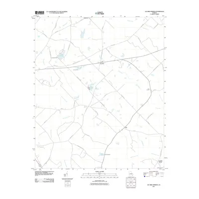
2011 Map of Jay Bird Springs
USGS Topo · Published 2011About this map
Gum Swamp Creek and its many tributaries, including Little Creek, Rock Branch, and Joiner Creek, create a complex network of waterways across this Georgia landscape. The map reveals a rural economy centered on local water resources, evidenced by infrastructure like the Lake Destiny Dam, Cranford Dam, Lowry Pond Dam, and Kelly Pond Dam. Small settlements such as Saunders, Pitts, and Mukerson are connected by a web of local roads, many bearing family names like Lester Saunders Rd and Jesse Peacock Rd. The resort area at Jay Bird Springs anchors the southeastern corner, while several family burying grounds, including Taylor Cemetery and Ryals Cemetery, provide significant points of interest for genealogical research and local history documentation.
Find a feature on this map
54 named features on this map. Tap any name to fly to it.
Don’t see what you’re looking for? This feature index may not catch every label — zoom into the map to look around manually.
Map Details
Editions of this 2011 Jay Bird Springs Map
This is the sole edition of this map. No revisions or reprints were ever made.
Other maps of this area

1957 · Macon
USGS Topo · 1:250,000

1958 · Macon
USGS Topo · 1:250,000

1964 · Macon
USGS Topo · 1:250,000

1972 · Eastman
USGS Topo · 1:24,000

1972 · Mc Rae NW
USGS Topo · 1:24,000

1972 · Jay Bird Springs
USGS Topo · 1:24,000
1972 · Milan
USGS Topo · 1:24,000
1972 · Mc Rae
USGS Topo · 1:24,000

1972 · Lake Cypress
USGS Topo · 1:24,000

1973 · Cadwell
USGS Topo · 1:24,000