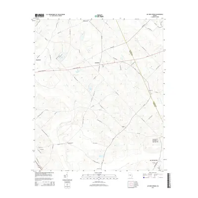
2014 Map of Jay Bird Springs
USGS Topo · Published 2014About this map
Jay Bird Springs anchors the southeastern corner of this Georgia landscape, situated along the line between Laurens and Dodge counties. The area is characterized by a dense network of watercourses and family-named landmarks, reflecting a long-established rural community south of Eastman. Small settlements like Saunders, Mukerson, and Pitts are connected by a web of local roads such as Kate Parkerson and Pete Sapp Rd, while several water bodies including Cranford Lake and Lowry Pond dot the terrain.
Find a feature on this map
72 named features on this map. Tap any name to fly to it.
Don’t see what you’re looking for? This feature index may not catch every label — zoom into the map to look around manually.
Map Details
Editions of this 2014 Jay Bird Springs Map
This is the sole edition of this map. No revisions or reprints were ever made.
Other maps of this area

1957 · Macon
USGS Topo · 1:250,000

1958 · Macon
USGS Topo · 1:250,000

1964 · Macon
USGS Topo · 1:250,000

1972 · Eastman
USGS Topo · 1:24,000

1972 · Mc Rae NW
USGS Topo · 1:24,000

1972 · Jay Bird Springs
USGS Topo · 1:24,000
1972 · Milan
USGS Topo · 1:24,000
1972 · Mc Rae
USGS Topo · 1:24,000

1972 · Lake Cypress
USGS Topo · 1:24,000

1973 · Cadwell
USGS Topo · 1:24,000