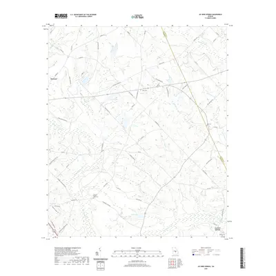
2020 Map of Jay Bird Springs
USGS Topo · Published 2020About this map
Gum Swamp Creek and a network of winding tributaries like Rock Br and Joiner Creek define this rural landscape along the border of Dodge and Laurens Counties. The terrain is a complex of agricultural fields and woodlands, anchored by the community at Jay Bird Springs in the southeast. For genealogists, the map preserves several local burial sites, including the Taylor Cem, Ryals Cem, and the McMillan Cem, alongside the Parkerson Baptist Church and its adjoining cemetery. The area's development is traced through a dense grid of local roads, such as Kate Parkerson Rd and Pete Sapp Rd, which connect remote homesteads to the nearby city of Eastman just off the western edge. Small water bodies like Cranford Lake and Kelly Pond are scattered throughout the drainage basins of the Ocmulgee River watershed.
Find a feature on this map
70 named features on this map. Tap any name to fly to it.
Don’t see what you’re looking for? This feature index may not catch every label — zoom into the map to look around manually.
Map Details
Editions of this 2020 Jay Bird Springs Map
This is the sole edition of this map. No revisions or reprints were ever made.
Other maps of this area

1957 · Macon
USGS Topo · 1:250,000

1958 · Macon
USGS Topo · 1:250,000

1964 · Macon
USGS Topo · 1:250,000

1972 · Eastman
USGS Topo · 1:24,000

1972 · Mc Rae NW
USGS Topo · 1:24,000

1972 · Jay Bird Springs
USGS Topo · 1:24,000
1972 · Milan
USGS Topo · 1:24,000
1972 · Mc Rae
USGS Topo · 1:24,000

1972 · Lake Cypress
USGS Topo · 1:24,000

1973 · Cadwell
USGS Topo · 1:24,000