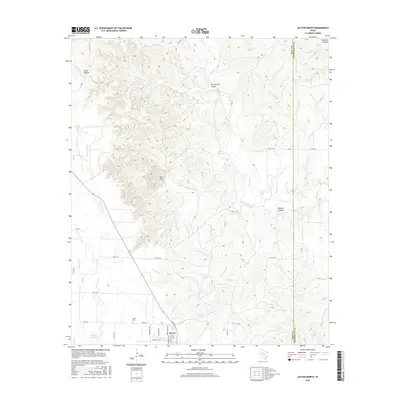
2016 Map of Jayton North
USGS Topo · Published 2016About this map
Jayton anchors the southern edge of this West Texas landscape, positioned where the grid of residential streets like Van Buren Ave and Washington Ave meets the open ranchland of Kent County. The settlement pattern is defined by its proximity to water resources in an arid environment, notably Jayton City Lake and specialized livestock infrastructure like Coker Tank and Railroad Tank. To the north, the terrain becomes increasingly complex as the Rolling Plains break into a network of drainage systems. Short Croton Creek and Little Duck Creek carve through the limestone and red bed soils, leading toward the expansive Salt Flat. This area is marked by significant topographic relief, including Hot Springs Canyon and Cedar Canyon, illustrating the erosional forces that have shaped this portion of the Texas Panhandle. The map also records the Kent and Stonewall county line, serving as a vital reference for researchers tracing property boundaries and local history.
Find a feature on this map
31 named features on this map. Tap any name to fly to it.
Don’t see what you’re looking for? This feature index may not catch every label — zoom into the map to look around manually.
Map Details
Editions of this 2016 Jayton North Map
This is the sole edition of this map. No revisions or reprints were ever made.
Other maps of this area

1954 · Lubbock
USGS Topo · 1:250,000

1958 · Pursley House
USGS Topo · 1:24,000

1958 · Southerland Canyon
USGS Topo · 1:24,000

1958 · Seven Diamond L Canyon
USGS Topo · 1:24,000

1958 · Jayton
USGS Topo · 1:24,000

1959 · Gilpin
USGS Topo · 1:24,000

1959 · Girard
USGS Topo · 1:24,000

1968 · Peacock
USGS Topo · 1:24,000

1969 · Clairemont East
USGS Topo · 1:24,000

1969 · Jayton South
USGS Topo · 1:24,000