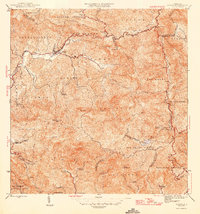
1946 Map of Jayuya
USGS Topo · Published 1946About this map
The town of Jayuya serves as the focal point for this mountainous landscape during the mid-1940s, situated at the confluence of the Rio Grande de Jayuya and its smaller tributaries. The map documents an extensive network of haciendas that defined the agricultural economy of the central cordillera, including Hacienda Santa Barbara, Hacienda Gripina, and Hacienda El Semil. These estates are distributed throughout the rugged terrain of barrios like Veguitas and Toro Negro, illustrating the historical land-use patterns of the region's coffee and fruit-growing era.
Find a feature on this map
68 named features on this map. Tap any name to fly to it.
Don’t see what you’re looking for? This feature index may not catch every label — zoom into the map to look around manually.
Map Details
Editions of this 1946 Jayuya Map
3 editions found
Other maps of this area

1945 · Ponce
USGS Topo · 1:30,000

1945 · Rio Descalabrado
USGS Topo · 1:30,000

1946 · Utuado
USGS Topo · 1:30,000

1946 · Ciales
USGS Topo · 1:30,000

1946 · Jayuya
USGS Topo · 1:30,000

1946 · Florida
USGS Topo · 1:30,000

1946 · Orocovis
USGS Topo · 1:30,000

1946 · Penuelas
USGS Topo · 1:30,000

1946 · Adjuntas
USGS Topo · 1:30,000

1947 · Ponce NE
USGS Topo · 1:10,000
Featured Places
- Jayuya
- Sector Estancias del Indio, Jayuya
- Salientito, Jayuya
- Sector El Carajo, Jayuya
- Villa Canonal, Jayuya