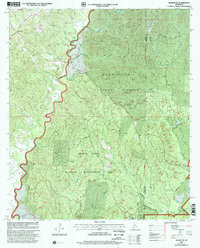
2000 Map of Jeannette
USGS Topo · Published 2002About this map
The Homochitto National Forest dominates the terrain of eastern Adams County, where the dense woodland is managed alongside active petroleum extraction. This 2000 revision reveals a landscape defined by the intersection of conservation and industry, notably at the Whites Creek Oil Field and Dry Bayou Oil Field. The small settlement of Jeannette sits at the northwestern edge near the intersection of Cranfield Road and Jeannette Rd, while the interior of the forest is accessed via timber and service roads like West Beach Road. Waterways such as Sandy Creek and Bayou Pierre carve through the management areas, where local genealogy is preserved at small sites like Carter Cem and Pine Grove Ch. The presence of the Washington Meridian line along the Adams Co and Franklin Co boundary marks a significant surveying point for Southwestern Mississippi land records.
Find a feature on this map
28 named features on this map. Tap any name to fly to it.
Don’t see what you’re looking for? This feature index may not catch every label — zoom into the map to look around manually.
Map Details
Editions of this 2000 Jeannette Map
This is the sole edition of this map. No revisions or reprints were ever made.
Other maps of this area

1921 · Natchez
USGS Topo · 1:48,000

1922 · Natchez
USGS Topo · 1:62,500

1939 · Natchez
USGS Topo · 1:62,500

1939 · Kingston
USGS Topo · 1:62,500

1953 · Natchez
USGS Topo · 1:250,000

1956 · Natchez
USGS Topo · 1:250,000

1958 · Kingston
USGS Topo · 1:62,500

1959 · Natchez
USGS Topo · 1:250,000

1961 · Crosby
USGS Topo · 1:62,500

1962 · Fayette
USGS Topo · 1:62,500