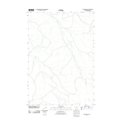
2011 Map of Jeans Fork NE
USGS Topo · Published 2011About this map
Sarpy Creek and its complex network of tributaries define this rural Big Horn County landscape at the turn of the decade. The area is characterized by the winding paths of the Middle Fork Sarpy Creek and East Fork Sarpy Creek, which converge to form the main stem as it flows northward through the high plains. This 2011 survey records the drainage patterns and primitive road network that connect isolated ranches and agricultural interests across the Big Horn area. To the southwest, the East Fork Tullock Creek carves a separate valley, while Little Hawk Creek appears in the southeast corner. The map provides a precise account of the drainage divides and topography that dictate land use in this sparsely populated region of Montana.
Find a feature on this map
5 named features on this map. Tap any name to fly to it.
Don’t see what you’re looking for? This feature index may not catch every label — zoom into the map to look around manually.
Map Details
Editions of this 2011 Jeans Fork NE Map
This is the sole edition of this map. No revisions or reprints were ever made.
Other maps of this area

1954 · Hardin
USGS Topo · 1:250,000

1957 · Hardin
USGS Topo · 1:250,000

1958 · Hardin
USGS Topo · 1:250,000

1958 · Chalky Point
USGS Topo · 1:24,000

1958 · Busby
USGS Topo · 1:24,000

1967 · Jeans Fork NW
USGS Topo · 1:24,000

1967 · Jeans Fork NE
USGS Topo · 1:24,000
1967 · Jeans Fork SE
USGS Topo · 1:24,000
1967 · Jeans Fork SW
USGS Topo · 1:24,000
1971 · Sarpy School
USGS Topo · 1:24,000