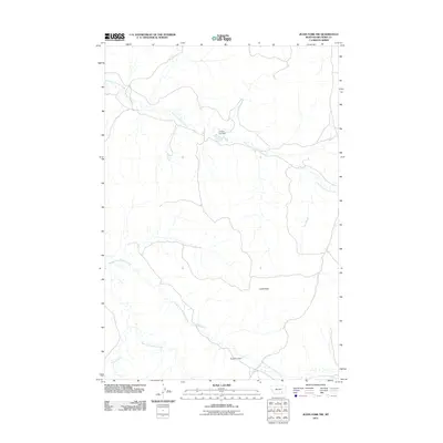
2011 Map of Jeans Fork NW
USGS Topo · Published 2011About this map
Castle Rock stands as a prominent landmark in this segment of the Big Horn County landscape, where the drainage systems of the Tullock Creek forks define the local geography. The area is characterized by its network of watercourses, including the East Fork Tullock Creek, Middle Fork Tullock Creek, and West Fork Tullock Creek. Small-scale water management features such as Tommy Tee Dam and the aptly named Forgotton Dam suggest the importance of water retention for ranching and livestock in this semi-arid region. Away from the primary creek beds, the map reveals the sparse road network and the isolation of the high plains, where Willow Creek joins the system of coulees and seasonal flows that have shaped this portion of the Montana range.
Find a feature on this map
7 named features on this map. Tap any name to fly to it.
Don’t see what you’re looking for? This feature index may not catch every label — zoom into the map to look around manually.
Map Details
Editions of this 2011 Jeans Fork NW Map
This is the sole edition of this map. No revisions or reprints were ever made.
Other maps of this area

1954 · Hardin
USGS Topo · 1:250,000

1957 · Hardin
USGS Topo · 1:250,000

1958 · Hardin
USGS Topo · 1:250,000

1967 · Jeans Fork NW
USGS Topo · 1:24,000

1967 · Jeans Fork NE
USGS Topo · 1:24,000

1967 · Crow Agency NE
USGS Topo · 1:24,000

1967 · Crow Agency SE
USGS Topo · 1:24,000
1967 · Jeans Fork SE
USGS Topo · 1:24,000
1967 · Jeans Fork SW
USGS Topo · 1:24,000
1972 · Padlock Ranch
USGS Topo · 1:24,000