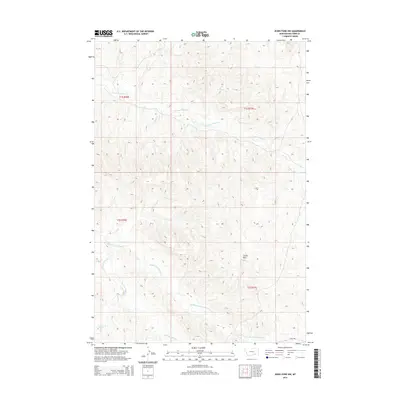
2014 Map of Jeans Fork NW
USGS Topo · Published 2014About this map
E Fork Tullock Cr and its sister tributaries dominate the landscape of Big Horn County on this 2014 survey. The area is characterized by the complex drainage system of the Tullock Creek forks, which carve through the high terrain of southeastern Montana. A prominent local landmark, Castle Rock, rises near the center of the sheet, providing a distinct navigational point above the surrounding basins. The drainage pattern of Middle Fork Tullock Cr, W Fork Tullock Cr, and Willow Cr illustrates the erosional forces that have shaped this portion of the Public Land Survey System, marked here by the intersection of Townships 1 and 2 South and Ranges 36 and 37 East. This map records the topography of these rural Montana highlands just as digital high-resolution imagery began to refine modern cartographic standards.
Find a feature on this map
9 named features on this map. Tap any name to fly to it.
Don’t see what you’re looking for? This feature index may not catch every label — zoom into the map to look around manually.
Map Details
Editions of this 2014 Jeans Fork NW Map
This is the sole edition of this map. No revisions or reprints were ever made.
Other maps of this area

1954 · Hardin
USGS Topo · 1:250,000

1957 · Hardin
USGS Topo · 1:250,000

1958 · Hardin
USGS Topo · 1:250,000

1967 · Jeans Fork NW
USGS Topo · 1:24,000

1967 · Jeans Fork NE
USGS Topo · 1:24,000

1967 · Crow Agency NE
USGS Topo · 1:24,000

1967 · Crow Agency SE
USGS Topo · 1:24,000
1967 · Jeans Fork SE
USGS Topo · 1:24,000
1967 · Jeans Fork SW
USGS Topo · 1:24,000
1972 · Padlock Ranch
USGS Topo · 1:24,000