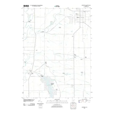
2010 Map of Jefferson
USGS Topo · Published 2010About this map
Lake Roaming Rock dominates the southern landscape of this Ashtabula County region, where the Roaming Rock Shores Lake Dam controls the waters of Rock Creek. The northern part of the survey is anchored by Jefferson, the county seat, featuring the Ashtabula County Fairgrounds and the Jefferson Post Office. A network of rural roads, such as Forman Rd and Lenox New Lyme Rd, connects established communities like Eagleville, Lenox Center, and Roaming Shores. Numerous cemeteries, including Oakdale Cemetery and West Lenox Cemetery, provide vital geographic markers for genealogists tracing family roots in the township. The natural drainage of the area is defined by the winding Grand River in the west and several smaller tributaries like Three Brothers Creek and Plum Creek, which cut through a landscape of family-held land such as Carousel Farm and Witt's End Farm.
Find a feature on this map
59 named features on this map. Tap any name to fly to it.
Don’t see what you’re looking for? This feature index may not catch every label — zoom into the map to look around manually.
Map Details
Editions of this 2010 Jefferson Map
This is the sole edition of this map. No revisions or reprints were ever made.
Other maps of this area

1905 · Andover
USGS Topo · 1:48,000

1905 · Ashtabula
USGS Topo · 1:62,500

1905 · Jefferson
USGS Topo · 1:62,500

1906 · Conneaut
USGS Topo · 1:62,500

1907 · Andover
USGS Topo · 1:62,500

1907 · Jefferson
USGS Topo · 1:62,500

1950 · Cleveland
USGS Topo · 1:250,000

1956 · Cleveland
USGS Topo · 1:250,000

1959 · Dorset
USGS Topo · 1:24,000
1959 · Windsor
USGS Topo · 1:24,000
Featured Places
- Jefferson, OH
- Jefferson Township, OH
- Morgan, Rock Creek
- Morgan Township, OH
- Roaming Shores, Morgan Township