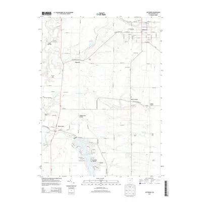
2013 Map of Jefferson
USGS Topo · Published 2013About this map
The Ashtabula County Fairgrounds serves as a focal point in the village of Jefferson, marking the northeastern portion of this Northeast Ohio landscape. The village's traditional grid is mirrored by surrounding agricultural and recreational development, from the Beaumonts Scout Reservation and Camp Yakewi to established family operations like Schossler Dairy and Witt's End Farm. Water shapes the western half of the terrain, where the Grand River flows near Cold Springs and the Riverdale Bridge. To the south, the man-made Lake Roaming Rock anchors the community of Roaming Shores, surrounded by modern residential street names like Conneaut Ter and Roaming Rock Blvd. This modern survey also preserves the location of rural hubs such as Eagleville, Rock Creek, and Lenox Center, alongside five local burial grounds including Oakdale Cem and Union Cem.
Find a feature on this map
85 named features on this map. Tap any name to fly to it.
Don’t see what you’re looking for? This feature index may not catch every label — zoom into the map to look around manually.
Map Details
Editions of this 2013 Jefferson Map
This is the sole edition of this map. No revisions or reprints were ever made.
Other maps of this area

1905 · Andover
USGS Topo · 1:48,000

1905 · Ashtabula
USGS Topo · 1:62,500

1905 · Jefferson
USGS Topo · 1:62,500

1906 · Conneaut
USGS Topo · 1:62,500

1907 · Andover
USGS Topo · 1:62,500

1907 · Jefferson
USGS Topo · 1:62,500

1950 · Cleveland
USGS Topo · 1:250,000

1956 · Cleveland
USGS Topo · 1:250,000

1959 · Dorset
USGS Topo · 1:24,000
1959 · Windsor
USGS Topo · 1:24,000
Featured Places
- Jefferson, OH
- Jefferson Township, OH
- Morgan, Rock Creek
- Morgan Township, OH
- Roaming Shores, Morgan Township