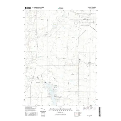
2016 Map of Jefferson
USGS Topo · Published 2016About this map
Jefferson serves as the focal point of this northern Ohio landscape, showing a dense grid of residential streets like W Walnut St and E Satin St centered around the county seat. Moving south, the terrain opens into a series of smaller rural hubs and agricultural tracts, including the settlements of Eagleville and Lenox Center. The Grand River and its tributaries, such as Mill Creek and Rock Cr, carve through the western half of the map, while the southern portion is dominated by the sprawling waters of Lake Roaming Rock at Roaming Shores. This modern survey reveals a landscape where historical cemetery sites like Oakdale Cem and Union Cem persist alongside recreational water features like Skidmore Lake and Reuschling Pond, illustrating the continued importance of both the river valleys and newer lakeside developments in Ashtabula County.
Find a feature on this map
81 named features on this map. Tap any name to fly to it.
Don’t see what you’re looking for? This feature index may not catch every label — zoom into the map to look around manually.
Map Details
Editions of this 2016 Jefferson Map
This is the sole edition of this map. No revisions or reprints were ever made.
Other maps of this area

1905 · Andover
USGS Topo · 1:48,000

1905 · Ashtabula
USGS Topo · 1:62,500

1905 · Jefferson
USGS Topo · 1:62,500

1906 · Conneaut
USGS Topo · 1:62,500

1907 · Andover
USGS Topo · 1:62,500

1907 · Jefferson
USGS Topo · 1:62,500

1950 · Cleveland
USGS Topo · 1:250,000

1956 · Cleveland
USGS Topo · 1:250,000

1959 · Dorset
USGS Topo · 1:24,000
1959 · Windsor
USGS Topo · 1:24,000
Featured Places
- Jefferson, OH
- Jefferson Township, OH
- Morgan, Rock Creek
- Morgan Township, OH
- Roaming Shores, Morgan Township