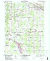
1994 Map of Jefferson
USGS Topo · Published 1997About this map
The Grand State Wild and Scenic River defines the western edge of this Ashtabula County landscape, winding through a region rooted in the Connecticut Western Reserve. The village of Jefferson serves as a primary hub, characterized by its grid of residential streets and the presence of the Fairground and Oakdale Cem. This mid-1990s record shows a rural-residential mosaic where agricultural land is intersected by numerous family-named roads like Hickok Road and Stumpville Road. Small crossroads and hamlets such as Lenox Center, Eagleville, and Turkey Foot Corner anchor the surrounding townships. Numerous watercourses, including Mill Creek and Plum Creek, drain toward the river, while several rural cemeteries such as West Lenox Cem and Union Cem offer essential points of interest for genealogists tracing long-established local lineages.
Find a feature on this map
50 named features on this map. Tap any name to fly to it.
Don’t see what you’re looking for? This feature index may not catch every label — zoom into the map to look around manually.
Map Details
Editions of this 1994 Jefferson Map
This is the sole edition of this map. No revisions or reprints were ever made.
Other maps of this area

1905 · Andover
USGS Topo · 1:48,000

1905 · Ashtabula
USGS Topo · 1:62,500

1905 · Jefferson
USGS Topo · 1:62,500

1906 · Conneaut
USGS Topo · 1:62,500

1907 · Andover
USGS Topo · 1:62,500

1907 · Jefferson
USGS Topo · 1:62,500

1950 · Cleveland
USGS Topo · 1:250,000

1956 · Cleveland
USGS Topo · 1:250,000

1959 · Dorset
USGS Topo · 1:24,000
1959 · Windsor
USGS Topo · 1:24,000
Featured Places
- Jefferson Township, OH
- Jefferson, OH
- Morgan, Rock Creek
- Morgan Township, OH
- Roaming Shores, Morgan Township