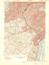
1941 Map of Jefferson Barracks
USGS Topo · Published 1950About this map
Jefferson Barracks and the sprawling Jefferson Barracks National Cemetery anchor this mid-century study of the southern St. Louis suburbs and the industrial riverfront. This era was defined by a landscape of institutional campuses and religious centers, including Eden Seminary, Kenrick Seminary, and the Notre Dame Convent. The Mississippi River remains the primary geographical axis, flanked by the Sugar Loaf Bottoms and the massive engineering of the River Des Peres Drainage Channel. Heavy rail infrastructure from the Missouri Pacific and St Louis San Francisco lines cuts through established communities like Webster Groves, Maplewood, and Affton, illustrating the region's growth from streetcar suburbs into a major metropolitan corridor. Numerous burial grounds and mausoleums, such as Mt Hope Mausoleum and Saints Peter and Paul Cemetery, are meticulously documented throughout the quadrangle.
Find a feature on this map
75 named features on this map. Tap any name to fly to it.
Don’t see what you’re looking for? This feature index may not catch every label — zoom into the map to look around manually.
Map Details
Editions of this 1941 Jefferson Barracks Map
3 editions found
Other maps of this area

1888 · St. Louis
USGS Topo · 1:62,500

1910 · Waterloo
USGS Topo · 1:62,500

1912 · Kimmswick
USGS Topo · 1:62,500

1913 · Waterloo
USGS Topo · 1:62,500

1916 · Kimmswick
USGS Topo · 1:62,500

1933 · Creve Coeur
USGS Topo · 1:24,000

1933 · Granite City
USGS Topo · 1:24,000

1933 · Jefferson Barracks
USGS Topo · 1:24,000

1933 · Cahokia
USGS Topo · 1:24,000

1933 · Clayton
USGS Topo · 1:24,000