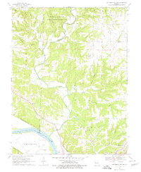
1969 Map of Jefferson City NW
USGS Topo · Published 1979About this map
The Missouri River corridor in Callaway and Boone Counties is defined by the winding course of Cedar Creek and a landscape transitioning from upland research areas to river bottomlands. In the late 1960s, the University of Missouri Ashland Wildlife Research Area occupied the northern hills, while the southern reaches of the map show the industrial and institutional footprint of the State Prison Farm near the riverbank. This era captures the region's transportation infrastructure at a peak, with the Missouri-Kansas-Texas and Missouri Pacific railroads following the river's path, supporting local Quarries and the burgeoning community of Holts Summit. Scattered country landmarks like Hopewell Ch and Mt Vernon Ch, alongside family burial grounds such as Shelley Cem and Wallace Cem, indicate a deeply rooted rural genealogy between the creek branches.
Find a feature on this map
35 named features on this map. Tap any name to fly to it.
Don’t see what you’re looking for? This feature index may not catch every label — zoom into the map to look around manually.
Map Details
Editions of this 1969 Jefferson City NW Map
3 editions found
Other maps of this area

1886 · Jefferson City
USGS Topo · 1:125,000

1894 · Jefferson City
USGS Topo · 1:125,000

1939 · Jefferson City
USGS Topo · 1:24,000

1939 · Jefferson City
USGS Topo · 1:62,500

1942 · Jefferson City
USGS Topo · 1:62,500

1944 · Millersburg
USGS Topo · 1:62,500

1946 · Millersburg
USGS Topo · 1:62,500

1947 · Jefferson City
USGS Topo · 1:250,000

1948 · Centertown
USGS Topo · 1:62,500

1948 · Columbia
USGS Topo · 1:62,500