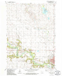
1986 Map of Jefferson West
USGS Topo · Published 1986About this map
The North Raccoon River carves a winding path across this Greene County landscape, anchoring a corridor of recreational and conservation land. Wildlife areas dominate the western and northern reaches, including the expansive Goose Lake State Wildlife Management Area and the Mc Mahon State Wildlife Management Area, which are punctuated by various Gravel Pits and local parks like Oak Hill County Park. This mid-1980s revision reflects a mix of agricultural township grids and established civic infrastructure.
Find a feature on this map
26 named features on this map. Tap any name to fly to it.
Don’t see what you’re looking for? This feature index may not catch every label — zoom into the map to look around manually.
Map Details
Editions of this 1986 Jefferson West Map
This is the sole edition of this map. No revisions or reprints were ever made.
Other maps of this area

1954 · Bagley
USGS Topo · 1:62,500

1954 · Omaha
USGS Topo · 1:250,000

1954 · Fort Dodge
USGS Topo · 1:250,000

1957 · Omaha
USGS Topo · 1:250,000

1957 · Fort Dodge
USGS Topo · 1:250,000

1958 · Omaha
USGS Topo · 1:250,000

1958 · Fort Dodge
USGS Topo · 1:250,000

1962 · Jefferson
USGS Topo · 1:62,500

1971 · Coon Rapids NE
USGS Topo · 1:24,000

1980 · Wightman
USGS Topo · 1:24,000