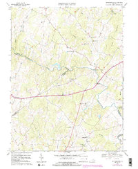
1966 Map of Jeffersonton
USGS Topo · Published 1984About this map
The Rappahannock River serves as a primary geographic boundary through this region, winding past historical crossroads like Waterloo and Cliff Mills. This 1966 survey, with 1980 updates, captures a Piedmont landscape defined by its network of watercourses, including Carter Run, Thumb Run, and Glascock Run. Rural life and community ties are evident in the density of landmarks such as Providence Ch near Orlean and the several Cem locations scattered throughout the hills.
Find a feature on this map
37 named features on this map. Tap any name to fly to it.
Don’t see what you’re looking for? This feature index may not catch every label — zoom into the map to look around manually.
Map Details
Editions of this 1966 Jeffersonton Map
3 editions found
Other maps of this area

1893 · Luray
USGS Topo · 1:125,000

1894 · Warrenton
USGS Topo · 1:125,000

1894 · Warrenton
USGS Topo · 1:62,500

1905 · Luray
USGS Topo · 1:125,000

1927 · Remington
USGS Topo · 1:48,000

1930 · Warrenton
USGS Topo · 1:62,500

1939 · Front Royal
USGS Topo · 1:48,000

1943 · Orlean
USGS Topo · 1:24,000

1943 · Marshall
USGS Topo · 1:24,000
1944 · Marshall
USGS Topo · 1:31,680