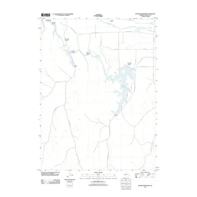
2011 Map of Jeffrey Reservoir
USGS Topo · Published 2011About this map
Jeffrey Reservoir dominates this portion of Lincoln County, serving as a critical node in the regional water management system of the early 21st century. Fed by the Tri-County Supply Canal, the reservoir is defined by its irregular, finger-like shoreline and several engineering landmarks, including the Earth Dam-Canal Mile 228 Dam. The surrounding landscape is a complex of canyons and Platte River bottomlands, where the Platte River itself flows past Chester Island in the north. The area's history is etched into its road names, with routes like S Fort McPherson Rd and E Fort McPherson Rd referencing the region's 19th-century military heritage. Deep drainages such as Snell Canyon and Conroy Canyon cut through the uplands, illustrating the contrast between the engineered water systems and the natural Nebraska topography.
Find a feature on this map
31 named features on this map. Tap any name to fly to it.
Don’t see what you’re looking for? This feature index may not catch every label — zoom into the map to look around manually.
Map Details
Editions of this 2011 Jeffrey Reservoir Map
This is the sole edition of this map. No revisions or reprints were ever made.
Other maps of this area

1899 · North Platte
USGS Topo · 1:125,000

1902 · Gothenburg
USGS Topo · 1:125,000

1902 · North Platte
USGS Topo · 1:125,000

1954 · McCook
USGS Topo · 1:250,000

1954 · North Platte
USGS Topo · 1:250,000

1956 · North Platte
USGS Topo · 1:250,000

1956 · Jeffrey Reservoir SW
USGS Topo · 1:24,000

1956 · Wellfleet SE
USGS Topo · 1:24,000

1956 · Wellfleet NE
USGS Topo · 1:24,000

1957 · North Platte
USGS Topo · 1:250,000