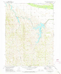
1970 Map of Jeffrey Reservoir
USGS Topo · Published 1973About this map
Jeffrey Reservoir dominates the center of this Lincoln County landscape, showing the integration of mid-century hydroelectric and irrigation infrastructure into the natural drainages south of the Platte River. The Tri-County Supply Canal feeds the reservoir, which sits at the head of several deep incisions in the loess hills, including Jeffrey Canyon and Conroy Canyon. This network was developed as part of the Department of the Interior program for the Missouri River Basin, indicated by the presence of a Powerplant and Substation at the reservoir's northern edge. To the north, the Platte River flows past Brady Island and Chester Island, where a Gaging Station monitors the river's discharge. The surrounding terrain is marked by intricate erosional features like Cottonwood Canyon and Snell Canyon, illustrating the complex topography of the Nebraska plains before it transitions into more open rangeland or agricultural fields.
Find a feature on this map
16 named features on this map. Tap any name to fly to it.
Don’t see what you’re looking for? This feature index may not catch every label — zoom into the map to look around manually.
Map Details
Editions of this 1970 Jeffrey Reservoir Map
This is the sole edition of this map. No revisions or reprints were ever made.
Other maps of this area

1899 · North Platte
USGS Topo · 1:125,000

1902 · Gothenburg
USGS Topo · 1:125,000

1902 · North Platte
USGS Topo · 1:125,000

1954 · McCook
USGS Topo · 1:250,000

1954 · North Platte
USGS Topo · 1:250,000

1956 · North Platte
USGS Topo · 1:250,000

1956 · Jeffrey Reservoir SW
USGS Topo · 1:24,000

1956 · Wellfleet SE
USGS Topo · 1:24,000

1956 · Wellfleet NE
USGS Topo · 1:24,000

1957 · North Platte
USGS Topo · 1:250,000