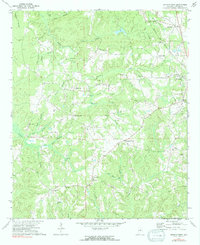
1971 Map of Jemison West
USGS Topo · Published 1991About this map
Jemison serves as the primary eastern anchor for this rural landscape, situated along the Louisville and Nashville railroad corridor. The area is defined by a dense network of small communities and family-named landmarks like Poseys Crossroads and Hubbard. Numerous rural spiritual and memorial sites are documented, including the Old Mars Hill Cem and churches like St James Ch and Shiloh Ch. The topography is intricately carved by a complex drainage system featuring Gold Mine Creek, Mohorn Creek, and Sixmile Creek. The distribution of Gravel Pits near the railroad indicates the localized industrial extraction present during the early 1970s. This survey records a traditional Alabama hill-country settlement pattern where small settlements like Center Hill and Campbell are connected by winding roads that follow the ridges between the numerous creek branches.
Find a feature on this map
51 named features on this map. Tap any name to fly to it.
Don’t see what you’re looking for? This feature index may not catch every label — zoom into the map to look around manually.
Map Details
Editions of this 1971 Jemison West Map
2 editions found
Other maps of this area

1890 · Bessemer
USGS Topo · 1:125,000

1891 · Clanton
USGS Topo · 1:125,000

1892 · Bessemer
USGS Topo · 1:125,000

1909 · Columbiana
USGS Topo · 1:62,500

1910 · Montevallo
USGS Topo · 1:62,500

1911 · Columbiana
USGS Topo · 1:62,500

1953 · Montgomery
USGS Topo · 1:250,000

1953 · Birmingham
USGS Topo · 1:250,000

1956 · Birmingham
USGS Topo · 1:250,000

1956 · Montgomery
USGS Topo · 1:250,000