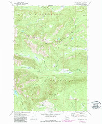
1970 Map of Jennies Butte
USGS Topo · Published 1987About this map
Goat Rocks Wilderness and the Yakima Indian Reservation meet at a complex boundary of high-country meadows and drainage divides in this late twentieth-century topographic study. The landscape is defined by the headwaters of the Tieton River and the Klickitat River, where the Campbell Line (1906-07) marks a significant historical surveying boundary across the Tenday Divide. Near the center of the sheet, Jennies Butte rises above the Jennies Butte Road, featuring a Lookout Tower that reflects the era's fire management infrastructure within the Gifford Pinchot National Forest. Geologically and hydrologically diverse, the area includes features like Soda Spring, Cedar Swamp, and the expansive Conrad Meadows. These landmarks illustrate the remote character of the Cascades before further modern development, preserved through wilderness and reservation designations.
Find a feature on this map
51 named features on this map. Tap any name to fly to it.
Don’t see what you’re looking for? This feature index may not catch every label — zoom into the map to look around manually.
Map Details
Editions of this 1970 Jennies Butte Map
2 editions found
Other maps of this area

1902 · Mount Aix
USGS Topo · 1:125,000

1904 · Mt Aix
USGS Topo · 1:125,000

1904 · Mount Adams
USGS Topo · 1:125,000

1907 · Mount Adams
USGS Topo · 1:125,000

1950 · Yakima
USGS Topo · 1:250,000

1958 · Yakima
USGS Topo · 1:250,000

1961 · Yakima
USGS Topo · 1:250,000

1962 · White Pass
USGS Topo · 1:62,500

1967 · Darland Mtn
USGS Topo · 1:24,000
1969 · Castile Falls
USGS Topo · 1:24,000