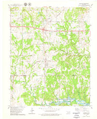
1978 Map of Jennings
USGS Topo · Published 1979About this map
Hallett and Jennings serve as the primary nodes of settlement in this landscape shaped by petroleum and rail history. This area at the intersection of the Pawnee Co Creek Co line features a complex geography of energy extraction, including the Lagoon Oil Field, McElroy Oil Field, and Tiger Oil Field. The industrial character is further defined by the St Louis-San Francisco and Missouri-Kansas-Texas railroads, which cross near Hallett Siding. A notable historical marker on the terrain is the Old Indian Territory-Oklahoma Boundary, which bisects the southern half of the map. To the southeast, the waters of Keystone Lake meet the Cimarron R, while an Old Railroad Grade north of Lagoon suggests the evolution of local transportation networks before the modern Cimarron Toll Road Turnpike was established.
Find a feature on this map
30 named features on this map. Tap any name to fly to it.
Don’t see what you’re looking for? This feature index may not catch every label — zoom into the map to look around manually.
Map Details
Editions of this 1978 Jennings Map
This is the sole edition of this map. No revisions or reprints were ever made.
Other maps of this area

1912 · Hominy
USGS Topo · 1:125,000

1915 · Hominy
USGS Topo · 1:125,000

1915 · Hominy
USGS Topo · 1:62,500

1929 · Yale
USGS Topo · 1:62,500

1929 · Skedee
USGS Topo · 1:62,500

1931 · Skedee
USGS Topo · 1:62,500

1932 · Yale
USGS Topo · 1:62,500

1955 · Enid
USGS Topo · 1:250,000

1958 · Enid
USGS Topo · 1:250,000

1966 · Cleveland
USGS Topo · 1:24,000