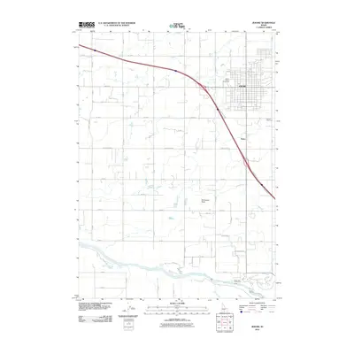
2010 Map of Jerome
USGS Topo · Published 2010About this map
Jerome serves as the focal point of this Magic Valley landscape, showing the organized grid of the city just north of its eponymous Jerome County Fairgrounds. The terrain transitions from the developed blocks of the town and small settlements like Hydra into a vast agricultural network defined by a rigorous grid of section roads, including Bob Barton Rd and Sunnyside Dr. To the south, the landscape drops dramatically toward the Snake River canyon. Here, the natural topography asserts itself with features like Sonnickson Butte and the winding paths of Rock Creek and Alpheus Creek. This 2010 survey captures the region's reliance on managed water and irrigation, evidenced by the proximity of Ellisons Spring and the Auger Falls Access Area along the river's edge.
Find a feature on this map
54 named features on this map. Tap any name to fly to it.
Don’t see what you’re looking for? This feature index may not catch every label — zoom into the map to look around manually.
Map Details
Editions of this 2010 Jerome Map
This is the sole edition of this map. No revisions or reprints were ever made.
Other maps of this area

1950 · Niagara Springs
USGS Topo · 1:24,000

1950 · Filer
USGS Topo · 1:24,000

1950 · Jerome
USGS Topo · 1:24,000

1950 · Jerome
USGS Topo · 1:62,500

1951 · Clover
USGS Topo · 1:24,000

1955 · Twin Falls
USGS Topo · 1:250,000

1958 · Twin Falls
USGS Topo · 1:250,000

1964 · Falls City
USGS Topo · 1:24,000

1964 · Twin Falls
USGS Topo · 1:24,000
1971 · Wendell
USGS Topo · 1:24,000