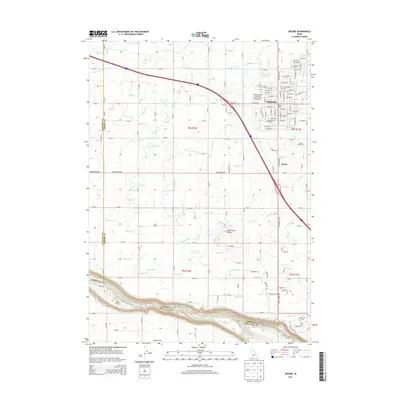
2013 Map of Jerome
USGS Topo · Published 2013About this map
Jerome serves as the central hub of this agricultural landscape in the early 21st century, its grid of streets and avenues bordered by the Jerome County Fairgrounds and the Jerome Game Farm. The surrounding terrain is defined by a dense network of irrigation channels, including the S Canal and J Canal, which sustain the farm plots of the Snake River Plain. To the south, the land drops away into the river canyon, where the Auger Falls Access Area provides a point of entry to the waterway. Distinctive local landmarks like Sonnickson Butte and Sucker Flat break the geometric regularity of the surveyed townships. Small aviation and transit points such as Ziggy's Airport and the settlement of Hydra highlight the rural infrastructure connecting this corner of Jerome County to the broader Magic Valley region.
Find a feature on this map
74 named features on this map. Tap any name to fly to it.
Don’t see what you’re looking for? This feature index may not catch every label — zoom into the map to look around manually.
Map Details
Editions of this 2013 Jerome Map
This is the sole edition of this map. No revisions or reprints were ever made.
Other maps of this area

1950 · Niagara Springs
USGS Topo · 1:24,000

1950 · Filer
USGS Topo · 1:24,000

1950 · Jerome
USGS Topo · 1:24,000

1950 · Jerome
USGS Topo · 1:62,500

1951 · Clover
USGS Topo · 1:24,000

1955 · Twin Falls
USGS Topo · 1:250,000

1958 · Twin Falls
USGS Topo · 1:250,000

1964 · Falls City
USGS Topo · 1:24,000

1964 · Twin Falls
USGS Topo · 1:24,000
1971 · Wendell
USGS Topo · 1:24,000