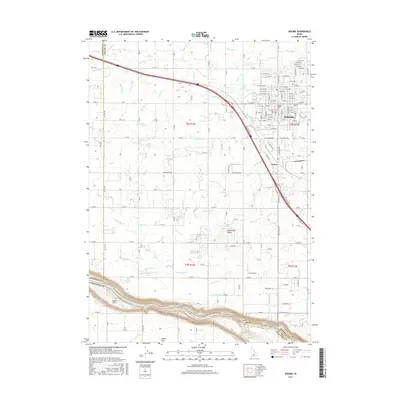
2017 Map of Jerome
USGS Topo · Published 2017About this map
Agricultural development and the complex water-management systems of the Magic Valley define this landscape north of the Snake River. The city of Jerome serves as a central hub for the region, showing a dense residential grid and industrial sections that support the surrounding farm economy. The terrain is remarkably level, punctuated only by occasional rises such as Sonnickson Butte and the broad expanse of Sucker Flat to the south.
Find a feature on this map
134 named features on this map. Tap any name to fly to it.
Don’t see what you’re looking for? This feature index may not catch every label — zoom into the map to look around manually.
Map Details
Editions of this 2017 Jerome Map
This is the sole edition of this map. No revisions or reprints were ever made.
Other maps of this area

1950 · Niagara Springs
USGS Topo · 1:24,000

1950 · Filer
USGS Topo · 1:24,000

1950 · Jerome
USGS Topo · 1:24,000

1950 · Jerome
USGS Topo · 1:62,500

1951 · Clover
USGS Topo · 1:24,000

1955 · Twin Falls
USGS Topo · 1:250,000

1958 · Twin Falls
USGS Topo · 1:250,000

1964 · Falls City
USGS Topo · 1:24,000

1964 · Twin Falls
USGS Topo · 1:24,000
1971 · Wendell
USGS Topo · 1:24,000