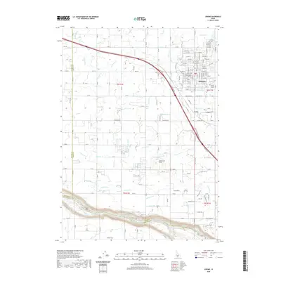
2020 Map of Jerome
USGS Topo · Published 2020About this map
The agricultural landscape of South-Central Idaho defines this area, where a dense network of irrigation laterals and canals supports the growth of Jerome. The city's grid is established around the Jerome County Judicial Annex and Aletheia Christian College, reflecting its role as a regional hub. South of the city, the terrain transitions into the canyons of the Snake River plain, marked by the prominent Sonnickson Butte and smaller clusters like Hydra and Nicole. Water management is the primary topographical feature here, with the S Canal, J Canal, and numerous specialized channels like M Canal-Waste creating a geometric pattern of human intervention across the basalt-rich soils. In the southwest, private aviation is represented by Zibby's Airport near the border with Gooding County.
Find a feature on this map
136 named features on this map. Tap any name to fly to it.
Don’t see what you’re looking for? This feature index may not catch every label — zoom into the map to look around manually.
Map Details
Editions of this 2020 Jerome Map
This is the sole edition of this map. No revisions or reprints were ever made.
Other maps of this area

1950 · Niagara Springs
USGS Topo · 1:24,000

1950 · Filer
USGS Topo · 1:24,000

1950 · Jerome
USGS Topo · 1:24,000

1950 · Jerome
USGS Topo · 1:62,500

1951 · Clover
USGS Topo · 1:24,000

1955 · Twin Falls
USGS Topo · 1:250,000

1958 · Twin Falls
USGS Topo · 1:250,000

1964 · Falls City
USGS Topo · 1:24,000

1964 · Twin Falls
USGS Topo · 1:24,000
1971 · Wendell
USGS Topo · 1:24,000