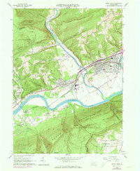
1965 Map of Jersey Shore
USGS Topo · Published 1973About this map
Jersey Shore serves as the focal point of this river valley survey, positioned where Pine Creek joins the West Branch Susquehanna River. The landscape is defined by the heavy infrastructure of the Penn Central railroad, including the extensive Avis Yard, which highlights the area's role as a transportation hub in the mid-1960s. The presence of several smaller communities like Avis, McElhattan, and Woolrich indicates a pattern of industrial and residential growth along the valley floor, contrasted sharply by the steep, wooded slopes of Bald Eagle Mountain and Short Mountain. Local history is anchored by landmarks such as the Jersey Shore Cemetery, Phelps Chapel, and the South Avis Sch, while the surrounding Tiadaghton State Forest and Bald Eagle State Forest show the preservation of timberlands around the developed river corridor.
Find a feature on this map
66 named features on this map. Tap any name to fly to it.
Don’t see what you’re looking for? This feature index may not catch every label — zoom into the map to look around manually.
Map Details
Editions of this 1965 Jersey Shore Map
4 editions found
Other maps of this area

1921 · Williamsport
USGS Topo · 1:48,000

1921 · Trout Run
USGS Topo · 1:62,500

1921 · Lock Haven
USGS Topo · 1:62,500

1923 · Lock Haven
USGS Topo · 1:62,500

1923 · Trout Run
USGS Topo · 1:62,500

1923 · Williamsport
USGS Topo · 1:62,500

1935 · Waterville
USGS Topo · 1:24,000

1937 · Waterville
USGS Topo · 1:48,000

1943 · Waterville
USGS Topo · 1:62,500

1944 · Trout Run
USGS Topo · 1:62,500