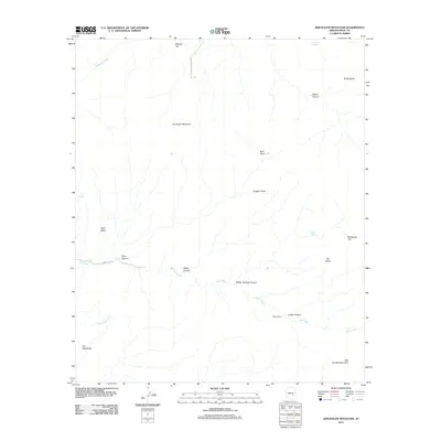
2011 Map of Jerusalem Mountain
USGS Topo · Published 2011About this map
Jerusalem Mountain rises as a central landmark in this high-desert terrain of Pinal and Gila counties. The landscape is defined by a complex drainage system where Deer Creek and McDougal Wash carve through numerous canyons, including Martin Canyon and Walker Springs Canyon. Human activity is sparse, concentrated primarily at Mings Ranch and along the unpaved corridors of Jerusalem Canyon Rd and Co RD 10. Historical land use is suggested by the distribution of water sources like Rockhouse Spring and Lime Spring, which were vital for cattle ranching in these arid basins. The varied topography, from the level heights of The Tablelands to the prominent Red Rooster Mountain, indicates a region shaped by erosion and seasonal water flow, long before more intensive modern development.
Find a feature on this map
24 named features on this map. Tap any name to fly to it.
Don’t see what you’re looking for? This feature index may not catch every label — zoom into the map to look around manually.
Map Details
Editions of this 2011 Jerusalem Mountain Map
This is the sole edition of this map. No revisions or reprints were ever made.
Other maps of this area

1911 · Winkelman
USGS Topo · 1:125,000

1913 · Winkelman
USGS Topo · 1:125,000

1915 · Christmas
USGS Topo · 1:62,500

1917 · Christmas
USGS Topo · 1:62,500

1938 · Klondyke
USGS Topo · 1:48,000

1943 · Klondyke
USGS Topo · 1:62,500

1949 · Holy Joe Peak
USGS Topo · 1:62,500

1949 · Saddle Mtn.
USGS Topo · 1:24,000

1949 · Brandenburg Mtn
USGS Topo · 1:24,000
1950 · Saddle Mtn.
USGS Topo · 1:24,000