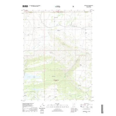
2020 Map of Jessen Butte
USGS Topo · Published 2020About this map
Ashley National Forest dominates the southern high ground of this borderlands survey, where the high desert of Wyoming meets the Uinta Mountains of Utah. The landscape is defined by the transition from the irrigated ranching lands of Lucerne Valley to the steep, wooded draws of the national forest. Water management is central to this environment, evidenced by the complex network of the Lodgepole Canal, S Valley Canal, and Sheep Cr Canal that move water across the arid basins. To the south, high-altitude water sources like Long Park Reservoir and Sheep Creek Lake sit at the headwaters of drainage systems that include Beaver Cr and Lodgepole Cr. A notable historical thread is preserved in the Carter Military road, while the lonely site of Dowds Grave near the eastern edge provides a specific point of local human history amidst the topographic features of Jessen Butte and Sheep Creek Hill.
Find a feature on this map
45 named features on this map. Tap any name to fly to it.
Don’t see what you’re looking for? This feature index may not catch every label — zoom into the map to look around manually.
Map Details
Editions of this 2020 Jessen Butte Map
This is the sole edition of this map. No revisions or reprints were ever made.
Other maps of this area

1885 · Ashley
USGS Topo · 1:250,000

1906 · Marsh Peak
USGS Topo · 1:125,000

1908 · Marsh Peak
USGS Topo · 1:125,000

1954 · Vernal
USGS Topo · 1:250,000

1954 · Rock Springs
USGS Topo · 1:250,000

1958 · Vernal
USGS Topo · 1:250,000

1958 · Rock Springs
USGS Topo · 1:250,000

1960 · Vernal
USGS Topo · 1:250,000

1962 · Rock Springs
USGS Topo · 1:250,000
1963 · Whiterocks Lake
USGS Topo · 1:24,000