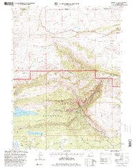
1996 Map of Jessen Butte
USGS Topo · Published 2000About this map
Ashley National Forest dominates the southern half of this landscape, where high-elevation terrain transitions into the deep canyons of the Geological Area. The historical Carter Military Trail winds through the southwestern corner near Beaver Creek, providing a tangible link to 19th-century logistics and movement across the Uinta Mountains. To the north, the topography softens into the Lucerne Valley, a drainage area for Sheep Creek and several irrigation canals supporting the settlement of Manila.
Find a feature on this map
41 named features on this map. Tap any name to fly to it.
Don’t see what you’re looking for? This feature index may not catch every label — zoom into the map to look around manually.
Map Details
Editions of this 1996 Jessen Butte Map
This is the sole edition of this map. No revisions or reprints were ever made.
Other maps of this area

1885 · Ashley
USGS Topo · 1:250,000

1906 · Marsh Peak
USGS Topo · 1:125,000

1908 · Marsh Peak
USGS Topo · 1:125,000

1954 · Vernal
USGS Topo · 1:250,000

1954 · Rock Springs
USGS Topo · 1:250,000

1958 · Vernal
USGS Topo · 1:250,000

1958 · Rock Springs
USGS Topo · 1:250,000

1960 · Vernal
USGS Topo · 1:250,000

1962 · Rock Springs
USGS Topo · 1:250,000
1963 · Whiterocks Lake
USGS Topo · 1:24,000