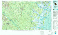
1981 Map of Jesup
USGS Topo · Published 1982About this map
The Altamaha River defines the southern reach of this coastal Georgia landscape, winding toward the Atlantic through a network of sounds and barrier islands. In the early 1980s, the region was characterized by the massive footprint of the Fort Stewart Military Reservation, which dominates the interior geography north of Hinesville. The map captures the complex transition from the inland pine forests and agricultural settlements like Ludowici and Jesup to the tidal marshes of the Medway River and North Newport River. Protected coastal lands are prominent, including the Harris Neck National Wildlife Refuge and Blackbeard Island National Wildlife Refuge. The transportation network relies on the Seaboard Coast Line Railroad and Southern Railway, which historically fueled the timber and naval stores industries of the coastal plain. Coastal communities like Shellman Bluff and Sunbury sit along the intricate estuaries and sounds, including Ossabaw Sound and St Catherines Sound.
Find a feature on this map
144 named features on this map. Tap any name to fly to it.
Don’t see what you’re looking for? This feature index may not catch every label — zoom into the map to look around manually.
Map Details
Editions of this 1981 Jesup Map
This is the sole edition of this map. No revisions or reprints were ever made.
Other maps of this area

1918 · Jesup
USGS Topo · 1:62,500

1918 · Hortense
USGS Topo · 1:62,500

1918 · Hinesville
USGS Topo · 1:62,500

1918 · Everett City
USGS Topo · 1:62,500

1919 · Claxton
USGS Topo · 1:62,500

1920 · Pembroke
USGS Topo · 1:62,500

1920 · Glennville
USGS Topo · 1:62,500

1920 · Meldrim
USGS Topo · 1:62,500

1920 · Wassaw Sound
USGS Topo · 1:62,500

1920 · Sapelo River
USGS Topo · 1:62,500