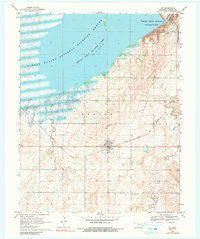
1969 Map of Jet
USGS Topo · Published 1991About this map
Great Salt Plains Lake dominates the northern half of this Alfalfa County landscape, where the waters are managed within the Salt Plains National Wildlife Refuge. The surrounding terrain, labeled simply as Saline, reflects the unique environmental character of this region. The town of Jet serves as the primary local hub, positioned at the intersection of the Atchison Topeka and Santa Fe railroad and regional roadways. To the east, the military presence of Kegelman Auxiliary Field (Vance Air Force Base) marks the plains, while the Great Salt Plains State Park provides recreation along the northeastern shoreline. Local heritage is preserved at the Pleasant View Cem, located north of the town center. The drainage patterns of Spring Creek, Twin Spring Creek, and Wagon Creek show the complex hydrology feeding into the salt-rimmed lake basin.
Find a feature on this map
13 named features on this map. Tap any name to fly to it.
Don’t see what you’re looking for? This feature index may not catch every label — zoom into the map to look around manually.
Map Details
Editions of this 1969 Jet Map
3 editions found
Other maps of this area

1955 · Woodward
USGS Topo · 1:250,000

1958 · Woodward
USGS Topo · 1:250,000

1969 · Jet
USGS Topo · 1:24,000

1969 · Goltry
USGS Topo · 1:24,000

1969 · Nash
USGS Topo · 1:24,000

1969 · Helena
USGS Topo · 1:24,000
1969 · Sand Creek
USGS Topo · 1:24,000

1969 · Manchester SW
USGS Topo · 1:24,000

1969 · Cherokee North
USGS Topo · 1:24,000

1969 · Jet SE
USGS Topo · 1:24,000